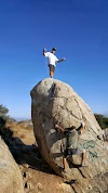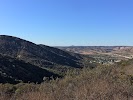

This is a different way to get to the top of Cowles Mountain really nice good work out and kids really enjoyed.
If you have lived here for awhile you have been in the mountains for one reason or another. And who hasnt gone swimming in the river or hung out at the sandpits or gone fishing or snuck on the back 9 when it was the back 9 at Carlton Oaks. Do you get the picture? And its all Free Santee enjoy yourself take pictures . Watch out for .️ Later gator
Definitely worth the effort. You can make it up in less than an hour and your efforts will be rewarded with great views all around. Two great photo signs show you what you are looking at in both directions. This is a much quieter route up than the one most people take. The service road gets very steep near the end so step carefully on your return trip.
Great views, an excellent hike and awesome excercise. I reccomend that anybody hike this trail!
Just nice. Plenty of good rocks to maneuver and switchbacks and steps, but the trail is easy to see and follow. People crossing your path are polite and its pretty with views over the valleys.
Nice mountain hike with good views and a gradual, easy, but challenging incline
My first run and it was worth every minute. Didnt know what I was dealing with at first so i started holiday with a spicy bloody Mary. Oh boy did i regret/sweat it out. Quality day off and a must for all locals.
Stay active. Stay outdoor. Boost immunity.
Cleqn fun trail
One of my favorite hiking trails. Its challenging with beautiful views. And if youre at Cowles Summit you may as well go the extra 1.5 miles to Pyles Summit and really enjoy a beautiful hiking adventure.
You can think of this as one of the back ways up Cowles Mountain. Youll encounter a fraction of people on the trail that youll pass on the main trail (from Golfcrest). The first half of the hike is a somewhat narrow trail with dense foliage in most places; halfway up, it connects with the fire road. While the fire road itself isnt much to look at, its here that youll probably start stopping to take photos of the expansive vistas over east San Diego. The last portion of the fire road becomes rather steep and is the most challenging portion of the hike (watch your footing on the way back down; its easy to start sliding if you go too fast). The fire road ends in a small saddle between the main peak and the communications tower area; from there you can scramble up a short set of stairs to the top and touch the mountains plaque.
Great way to add some length to a hike up Cowels Mountain. Ease into the climb on a less traveled, slightly shaded trail.
Good less traveled path to Cowels
Nice way to avoid the crowds when hiking up to Cowels Mountain with plenty of parking and a public restroom at the park next to the trail head
Big Rock Trail has a nice longhiking trail and it also has a big dog park and barbecue place very nice..
Need more signage. Very hard for beginners. Got lost on way back down and waswith a child.No lighting for those who dont get back down before sunset so cant see trail and VERY SCARY.
Good hiking trail but hard. Lots of rocks to walk on. Bring water as you well get hot.
Great trails to run. Be careful for snakes.
Great trail for a half-day/early morning hiking trip. The total distance (from the trail head on Big Rock rd to the Cowles summit and back) is a little over 5 miles. The majority of the trail is fairly light and very well maintained. Only the last less than half mile right before the summit is a bit steep and would need shoes with better gripping (especially the downhill part). The trail might be less crowded than the Cowles trail starting from the big parking lot. But there is still (pleasantly) constant hiker flow on it. Needless to say the view from the summit is gorgeous. That said, the only problem is that there is no rest room at the trail head, nor is there any at the summit. So hikers need to be prepared.
Streams are back for meditation!
Very serene. There arent many people on the trail because its difficult. That being said, it really isnt that bad. Take your time, bring water, enjoy the scenery and bask in the wonderful soundtrack of Big Rock Trail.
It was fun but I expected more.
Great place for a morning walk height, very serene
360 views, trail to start but turns into gravel road. Connects with Pyles Mtn. trail at the top.
Its the best place to climb Cowels Mountain! Its longer and less crowded! 5 miles and 1500 elevation change one way!
Love this trail and its near home
Another area to mountain bike.
Watch your ankles here! Be sure to wear good footwear that gives ankle support but doesnt blister. I had to learn that the hard way, haha
Much less traffic than the main cowles trail. Meets up with the fire road.
Very windy, and very steep..Definiately say for skilled hikers, but I saw kids at the summit too so I guess according to your family. Would return again!
Its my preferred route up Cowles Mountain.
Apparently this is the more difficult route to take up to the top of Cowles Mtn. Which made me feel like the man. Nice hike. Only gets treacherous as you get close to the top --it gets realllll steep.
Kicked my butt hiking,great workout!
Cool
Great alternative to the south side trail
This is the much less crowded side to hike Cowels mountain.
Hikers daydream
Amazing
Nice
Challenging but achievable
Cool
Amazing hike
A hicking we will go
This is the back side of the Mission Gorge Trail, with less people.
- Address:8301 Big Rock Rd, Santee, CA 92071, United States
- Site:https://alltrails.com/trail/us/california/big-rock-trail
- Tourist attraction
- Hiking area
- Monday:Open 24 hours
- Tuesday:Open 24 hours
- Wednesday:Open 24 hours
- Thursday:Open 24 hours
- Friday:Open 24 hours
- Saturday:Open 24 hours
- Sunday:Open 24 hours
- Wheelchair-accessible entrance:No
- Good for kids:Yes
Similar organizations
- Town Center Community Park550 Park Center Dr, Santee, CA 92071, United States
- Mast Park Disc Golf Course9125 Carlton Hills Blvd, Santee, CA 92071, United States
- Deputy Ken Collier Playground9206-9236 Via De Cristina, Santee, CA 92071, United States
- Shadow Hill Park9161 Shadow Hill Rd, Santee, CA 92071, United States
- Creation & Earth History Museum & Bookstore10946 N Woodside Ave, Santee, CA 92071, United States
- Woodglen Vista Park10250 Woodglen Vista Dr, Santee, CA 92071, United States
- Sky Ranch Park5822-5998 Cala Lily St, Santee, CA 92071, United States
- Big Rock Park8125 Arlette St, Santee, CA 92071, United States
- West Hills Park8790 Mast Blvd, Santee, CA 92071, United States
- Santee Historical Society and Historic Barn9200 N Magnolia Ave, Santee, CA 92071, United States