
El Toro Wilderness

Photos


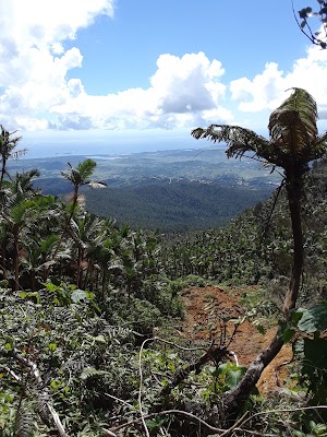


It is a very challenging trail. Must be in good health condition. Must bring plenty water, snacks, to keep you on track. I measured the trail with the GPS and is about 3.19 miles each way. The highest elevation point is 3,648 ft above sea level. It might rain during the way, be prepare. There is T-Mobile phone and data signal during the way. Make sure dont leave any garbage during the way. Have lots of fun, enjoy life!
El Toro Wildernis is accessible using the El Toro Trail which starts at road 186. After 2.5 miles one ends up on El Toro with fantastic views. The trail can be very muddy, so best in the dry season December to March.

Loved the hike but I had to use my machete to cut some of the way

Not for amateurs but the unique scenic view from the top is well worth the challenge. Ideally bring food to snack and rest up there while enjoying the view. I timed a solid pace without stopping of 1hr35m going up, and 1hr15m coming down. Make sure to wear hiking boots (the soil is pretty muddy, it will get messy) and long sleeves (so you don’t get scratched by branches). Bring water, bug spray and wear sunscreen. The good thing is you can’t get lost, there is one trail and is clearly marked the hole way, no posible deviations.
Trailhead is at KM 10.8 on Route 186. There are many muddy sections, which was no problem for me wearing 8 hiking boots with Vibram soles. The ones in our group wearing sneakers struggled for traction. There are no creeks or waterfalls along this trail. It is an occasionally steep trail to the top of the mountain and the effort is so worth it !
- Address:Las Piedras, 00771, Puerto Rico
- Site:https://fs.usda.gov/recarea/elyunque/recarea/?recid=43417
- Phone:+1 787-888-1880
- Tourist attraction
- National forest
- Wheelchair-accessible entrance:No
- Good for kids:Yes
Similar organizations
- Macromural Pintalto Las Piedras13 Cll Joaquin Poupart, Las Piedras, 00771, Puerto Rico
- CuCueva del IndioUrb. Est. De Los Artesanos, Las Piedras, 00771, Puerto Rico
